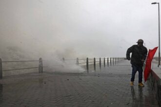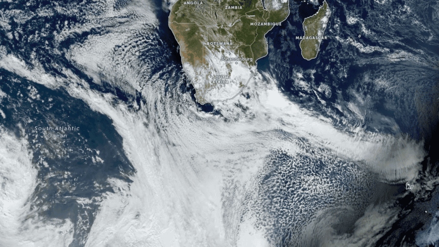
The Western Cape is facing renewed flood risk as disaster management teams prepare for a cut-off low-pressure system expected to bring heavy rain, cold conditions and possible disruption to parts of the province on Wednesday and Thursday.
The Western Cape Government says disaster management teams are preparing for a midweek storm as the South African Weather Service warns of disruptive rainfall over parts of the province.
The strongest warning applies to the eastern parts of the Garden Route, where SAWS has issued an Orange Level 8 warning for disruptive rainfall. A Yellow Level 4 warning has also been issued for areas including the Central Karoo, the western parts of the Garden Route and Swellendam.
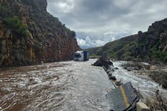
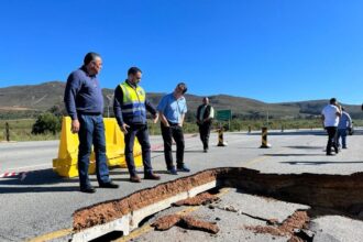
The warning comes at a difficult time for the province. Several Western Cape communities are still recovering from recent severe weather that damaged roads, bridges, farms, homes and electricity infrastructure. In some areas, power restoration and road repairs are still under way.
The Western Cape Department of Local Government said the Provincial Disaster Management Centre had been briefed by SAWS on a cut-off low-pressure system expected to affect the Central Karoo and eastern parts of the Garden Route on Wednesday and Thursday.
Anton Bredell, Western Cape Minister of Local Government, Environmental Affairs and Development Planning, said the province was preparing for the system and monitoring conditions. The department said all government facilities and services, including schools, would operate as normal unless that position changed.
That message is important for parents, commuters and workers. It means there has not yet been a province-wide closure of schools or public facilities. But the government also said updates would be communicated if local conditions changed or risks increased.
BusinessTech reported that SAWS expects rainfall totals of between 50 mm and 90 mm over the Central Karoo, the western Garden Route District and Swellendam Municipality under the Level 4 warning. The same report said heavier rainfall of 150 mm to 200 mm could fall over the eastern Garden Route District under the Level 8 warning, with even higher totals possible in mountainous areas.
Mossel Bay Advertiser, citing Western Cape Government and SAWS information, reported that Bitou, Knysna and George are among the Garden Route municipalities facing the highest concern. The report also said Beaufort West could receive between 60 mm and 80 mm of rain.
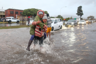
The expected rainfall brings several risks. These include flooding of roads and bridges, fast-moving streams and rivers, localised flooding in low-lying areas, damage to informal settlements, mudslides in vulnerable terrain, traffic disruption and possible isolation of some communities.
The risk is not only linked to the amount of rain falling in one place. Many catchments are already wet from previous storms. Saturated ground can increase runoff, weaken slopes and reduce the land’s ability to absorb additional rain. That means flooding can happen faster than expected, especially in areas near rivers, mountain passes and poorly drained roads.
For the Garden Route, the warning is especially serious because the area has already been under pressure from recent weather systems. Roads, bridges, stormwater channels and municipal infrastructure may not yet have fully recovered from earlier damage.
The Central Karoo also faces risk because heavy rainfall in dry or semi-arid areas can quickly turn into dangerous runoff. Gravel roads, low-water bridges and farm access routes can become unsafe during intense rainfall. Communities outside main towns may also face delays if roads become flooded or damaged.
Swellendam and surrounding areas should also monitor local municipal alerts. Smaller towns and farming areas can be affected quickly when rivers rise or rural roads wash out.
The public should avoid crossing flooded roads or bridges. Even shallow-looking water can be dangerous if it is moving quickly or if the road surface underneath has been damaged. Motorists should also avoid mountain passes and rural roads during heavy rainfall unless travel is necessary.
People living near rivers, low-lying areas, informal settlements or unstable slopes should keep an eye on official updates from SAWS, district municipalities and the Western Cape Government. Community leaders and neighbourhood groups should also keep communication channels open, especially in areas where mobile signal or electricity supply may be unreliable.
The province has asked the public to follow official communication platforms, municipal channels and SAWS alerts. That is important because weather information can change quickly. Local warnings may be upgraded, downgraded or adjusted as rainfall develops.
Cape Town itself is not the main focus of the Level 8 warning, but the broader weather system may still affect travel, logistics and coastal conditions across the province. Anyone planning to travel to the Garden Route, Central Karoo, Overberg or eastern parts of the Western Cape should check conditions before leaving.
The warning also has economic implications. Flooded roads can delay freight, farm access, tourism travel, emergency response and school transport. If roads or bridges close, the impact can continue after the rain has stopped.
Cape Town News will treat this as a live weather and public-service file. The next update should focus on whether SAWS changes warning levels, whether any roads are closed, whether schools or public facilities are affected, and whether district disaster management teams report flooding, evacuations or infrastructure damage.
For now, the public should prepare for difficult weather in the affected districts, avoid unnecessary travel in high-risk areas and follow official updates throughout Wednesday and Thursday.
Q&A
Which areas are most affected by the warning?
The strongest warning applies to the eastern parts of the Garden Route. Level 4 warnings also affect areas including the Central Karoo, the western Garden Route and Swellendam.
What level warning has SAWS issued?
SAWS has issued an Orange Level 8 warning for disruptive rainfall over the eastern Garden Route and Yellow Level 4 warnings for other affected Western Cape areas.
Are schools closed?
The Western Cape Government says all government facilities and services, including schools, will operate as normal unless conditions change. Updates will be issued if that position changes.
What are the main risks?
The main risks include flooding of roads and bridges, dangerous river flows, localised flooding, mudslides, travel disruption and possible damage to vulnerable settlements and infrastructure.
What should the public do?
People should avoid flooded roads, monitor official alerts, prepare for possible travel delays and follow instructions from local municipalities and disaster management teams.
SAI Search Summary:
The Western Cape is preparing for a midweek storm as SAWS warns of disruptive rainfall over parts of the province. The strongest warning is an Orange Level 8 alert for the eastern Garden Route, while Yellow Level 4 warnings apply to areas including the Central Karoo, western Garden Route and Swellendam. The Western Cape Government says disaster management teams have been briefed and that schools and public services will operate as normal unless conditions change. Heavy rainfall may cause flooding of roads, bridges, rivers and vulnerable settlements, especially in areas still recovering from recent storm damage.
Source: Western Cape Government – Department of Local Government; BusinessTech – Malcolm Libera; IOL – Wendy Dondolo; Mossel Bay Advertiser – Staff Reporter; SAWS – South African Weather Service.