Cape Town’s road network came under sustained pressure over the weekend as a series of cold fronts brought heavy rain and strong winds, flooding major routes, disrupting traffic flow, and forcing authorities to respond to widespread incidents across the metro.
As the system moved across the Western Cape, localised flooding developed rapidly in low-lying and poorly drained areas, turning sections of the city’s road network into temporary waterways. The combination of persistent rainfall and saturated ground conditions meant that water was slow to disperse, particularly in areas where stormwater systems were already under strain.
Disaster Risk Management teams were deployed across affected areas, responding to incidents reported through the city’s Transport Management Centre. These included flooded roads, blocked drainage systems, and hazards caused by debris and fallen trees.
“Several roads in Parkwood have been affected,” said Disaster Risk Management spokesperson Sonica Lategan, confirming that the impact extended across multiple parts of the metro.
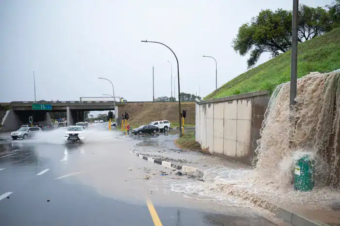
The disruption was not limited to residential streets. Key transport corridors were also affected, with standing water reducing lane capacity and slowing traffic along major routes. The N1 outbound near the Wingfield interchange experienced partial lane obstructions, while coastal routes such as Simon’s Town Main Road and Kalk Bay Main Road were also impacted by water pooling and reduced visibility.
Further inland, flooding was reported along Bottelary Road, Frans Conradie Drive in Kraaifontein, and Jip de Jager Drive in Bellville, contributing to congestion and extended travel times as motorists navigated hazardous conditions.
Heavy rain and strong winds compounded the situation, creating dangerous driving conditions across the metro. Reduced visibility, slippery road surfaces, and waterlogged sections increased the risk for motorists, particularly during peak traffic periods.
“Disaster Risk Management officials will be conducting assessments in the Mkhonto Square Informal Settlement in Nyanga, as well as Brown’s Farm,” Lategan said, highlighting the broader impact of the weather system across both residential and transport infrastructure.
“Our Disaster Operations Centre received reports that structures in these areas have been affected by the heavy downpours, although the extent can only be confirmed once assessments are completed,” she added, pointing to the ongoing nature of response efforts.
One of the most significant precautionary measures was the closure of Chapman’s Peak Drive, a route known for its vulnerability during severe weather events. Authorities shut the road due to the risk of rockfalls and unsafe driving conditions, placing additional pressure on alternative routes and increasing congestion across the network.
The scale of the disruption has once again raised concerns about the resilience of Cape Town’s stormwater systems, particularly in areas where rapid urban growth has placed additional demands on existing infrastructure. Blocked drains, limited capacity, and the intensity of rainfall all contributed to the slow movement of water through the system.
While weather conditions are expected to gradually improve, officials warn that the impact of the storm will continue to be felt in the short term. Water levels in some areas remain slow to recede, and the clean-up process is expected to take time as city teams continue to respond to outstanding incidents.
Authorities have urged motorists to remain cautious, avoid flooded roads, and allow for additional travel time as the city works to restore normal conditions.
The weekend’s events underline the growing challenge of managing extreme weather in an urban environment, where infrastructure, population density, and climate variability intersect. As Cape Town moves deeper into the winter season, the focus now shifts to recovery efforts and the need for continued investment in resilient stormwater and transport systems to better withstand future weather events.
Credit: IOL – Wendy Dondolo.