Meiringspoort: One of the Western Cape’s most important road links between the Klein Karoo and the interior remains severed after floodwater tore through the mountain pass, washed away sections of the N12 and exposed the foundations beneath stretches of asphalt. Engineers are now examining damaged bridges, retaining structures and road layers to determine where repairs are possible and where the route may need to be rebuilt, leaving travellers, farmers and freight operators facing extended detours with no confirmed reopening date.
Floodwater Cut Through The N12
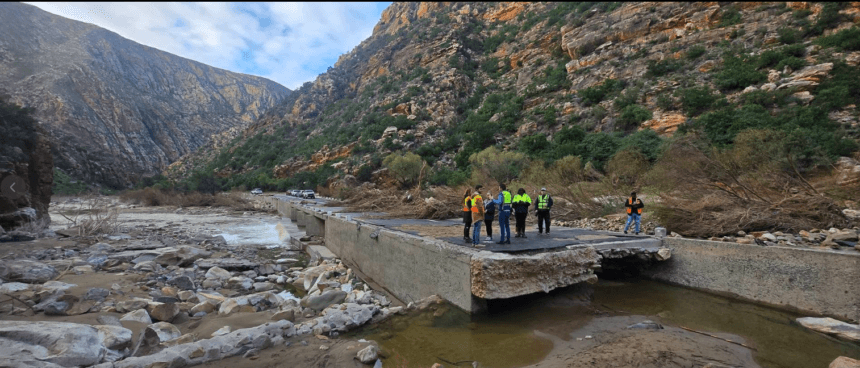
Meiringspoort was closed after severe flooding swept through the pass on 6th May.
The N12 runs alongside and repeatedly crosses the Groot River between De Rust and Klaarstroom, making the route particularly vulnerable when large volumes of water move through the narrow mountain valley.
Photographs released by the Western Cape Government show extensive damage rather than ordinary potholes or surface erosion.
In several places, floodwater stripped away soil and aggregate beneath the tar, leaving sections of asphalt suspended above open cavities. Other images show broken road edges, exposed foundations, debris deposits and damage close to retaining structures and bridge approaches.
The extent of the erosion means the road cannot simply be reopened after mud and stones are cleared.
Engineers must establish whether the remaining pavement has sufficient support, whether riverbanks are stable and whether structures can carry normal traffic loads without further failure.
What Has Been Damaged
| Infrastructure Component | Reported Condition |
| Road surface | Sections broken, undermined or washed away |
| Road foundation | Material removed beneath sections of asphalt |
| Bridge approaches | Flood and erosion damage under assessment |
| Retaining structures | Damage and exposed sections reported |
| River crossings | Debris, sediment and erosion affecting structures |
| Road shoulders | Washed away or destabilised in places |
| Drainage systems | Inspection and clearing required |
| Reopening date | Not yet confirmed |
The visible damage is only one part of the assessment.
Water can weaken material beneath a road without leaving an obvious failure on the surface. Engineers may therefore need to test pavement layers, foundations and structures beyond the areas where the asphalt has already collapsed.
Minister Inspects The Damage
Western Cape Infrastructure Minister Tertuis Simmers joined departmental teams inspecting damaged roads and structures as the provincial government moved from emergency response towards long-term recovery.
Simmers said roads, bridges and related infrastructure across the province had suffered significant damage during the recent storms.
Some structures would require major repairs, while others could need complete reconstruction.
The department’s immediate focus has been restoring access to isolated communities, emergency services and essential economic routes.
However, reopening a mountain pass before its structures are stable would expose travellers and repair teams to serious danger.
The government has repeatedly urged road users to obey closure signs and avoid attempting to enter roads declared unsafe.
Meiringspoort Closure At A Glance
| Detail | Current Position |
| Route | N12 through Meiringspoort |
| Closed section | Between De Rust and Klaarstroom |
| Initial closure | 6th May |
| Cause | Severe flooding and road washaways |
| Access | Closed to ordinary traffic |
| Assessment | Engineers inspecting road and structural damage |
| Repair scale | Major repairs or reconstruction may be required |
| Reopening | No confirmed date announced |
The latest official road-closure information continued to list Meiringspoort as closed.
Capetonians and other travellers planning journeys through the Klein Karoo should verify official updates before departure rather than relying solely on navigation applications.
Online route services can occasionally direct drivers towards roads that remain officially closed or unsafe.
Why The Route Matters
Meiringspoort is more than a scenic tourist drive.
The pass forms part of the N12 connection between Oudtshoorn, Beaufort West and the national road network serving the interior.
It carries private vehicles, tour buses, delivery trucks, agricultural traffic and freight moving between the Garden Route, Klein Karoo and Central Karoo.
When the pass is open, travellers can move directly between De Rust and Klaarstroom through the Swartberg mountain range.
The closure forces vehicles onto longer alternatives, increasing travel time, fuel use and transport costs.
For freight operators, the effect can accumulate quickly. A detour adds distance to every delivery, while delays make it more difficult to meet collection times, warehouse schedules and customer commitments.
Farmers and rural businesses may also depend on the route for supplies, livestock transport and access to markets.
Alternative Routes Add Time And Cost
Authorities have previously directed travellers towards alternative routes through the wider Garden Route and Karoo network.
The correct detour depends on the driver’s starting point, destination and the status of other roads.
Travellers moving between Oudtshoorn and Beaufort West may need to use routes through George, Uniondale, Willowmore or Aberdeen before reconnecting with roads towards the Central Karoo.
These alternatives can add substantial distance compared with travelling directly through Meiringspoort.
Road users must also check the condition of the R328 near the Cango Caves, the Swartberg Pass and other routes that have experienced rockfalls, erosion or weather-related closures.
A detour that appears shorter on a map may not be suitable for heavy vehicles, caravans or ordinary passenger cars.
Drivers should use routes approved by provincial traffic authorities and avoid gravel or mountain roads unless they are certain those roads are open and safe.
Recovery Complicated By Repeated Storms
The Western Cape has experienced several major weather systems in quick succession.
This has complicated road recovery because crews repairing one site have faced further rain, flooding, erosion and rockfalls before preliminary work could be completed.
On the R328 near Oudtshoorn, specialist teams had been stabilising a major rockfall site when another severe storm between 3rd and 5th June damaged some of the temporary work.
Meiringspoort faces similar difficulties because repair teams must work inside a narrow river valley where weather, water levels and unstable ground can affect access.
Before reconstruction begins, engineers must understand how the river changed during the flood.
If the watercourse shifted, deepened or removed protective material, restoring the road to its previous condition may not provide enough protection against another severe event.
Repairs may therefore require stronger retaining structures, redesigned drainage, improved erosion protection or adjustments to sections of the road.
Provincial Storm Damage Exceeds R9 Billion
The Meiringspoort damage forms part of a much larger provincial disaster.
The Western Cape Government’s preliminary assessment placed the broader cost of recent storm damage above R9 billion.
The figure includes harm to roads, bridges, municipal services, homes, agriculture, schools and other public infrastructure.
About 70% of roads closed during the storms had been reopened in some form by 18th June, according to Premier Alan Winde.
That progress restored access to many communities and businesses, but the remaining closed routes include some of the most technically difficult repair sites.
A washed-away road can take far longer to restore than a route blocked by debris.
The province must also prioritise projects because available emergency and infrastructure funding cannot immediately cover every damaged site.
Why Engineers Cannot Announce A Date Yet
Road users often want a clear reopening date, but engineers can only provide one once the scale of the work is understood.
The assessment process may include:
surveying the damaged road alignment;
checking bridge foundations and structural elements;
testing road layers and supporting material;
measuring riverbank erosion;
inspecting drainage and culverts;
determining whether temporary access is safe;
designing permanent repairs;
calculating quantities and costs;
appointing contractors or emergency teams;
and securing construction material and machinery.
Even when a temporary lane appears possible, the department must consider whether another rainfall event could place vehicles at risk.
Meiringspoort contains several narrow sections where turning heavy vehicles around would be difficult if conditions deteriorated.
Authorities are therefore likely to keep the route closed until they are satisfied that traffic can move through safely and that construction activity will not create additional hazards.
Economic Effects Extend Beyond Tourism
Tourism businesses in De Rust, Oudtshoorn, Prince Albert and surrounding areas depend partly on travellers using the pass.
Restaurants, guest houses, fuel stations, shops and roadside attractions can lose passing trade when vehicles are redirected elsewhere.
Tour operators may need to change itineraries, while visitors planning scenic journeys through the poort must find alternative attractions or routes.
The wider impact reaches agriculture and freight.
The Klein Karoo economy includes farming, ostrich production, fruit, wine, tourism and manufacturing. These sectors depend on reliable roads to move workers, equipment, produce and goods.
Long detours effectively increase the cost of doing business in towns and rural areas already separated by considerable distances.
Road Users Warned Against Entering Closed Areas
A formal road closure is not a suggestion.
Drivers who move barriers or attempt to use damaged sections may place themselves, passengers and emergency responders in danger.
Undermined asphalt can collapse under the weight of a vehicle even where the surface still looks intact.
Flood-damaged bridge approaches can also fail suddenly if supporting soil has been removed.
People entering the closed pass may interfere with engineering inspections or construction machinery.
Insurance claims could also become complicated where a driver knowingly enters a road closed by authorities.
The safest approach is to plan the full journey before departure, allow additional travel time and carry sufficient fuel, water and emergency supplies for the longer route.
What Travellers Should Do
Before travelling between the Garden Route, Klein Karoo and Central Karoo, drivers should consult current Western Cape Government road-closure notices.
They should also check updates from the Garden Route District Municipality and local traffic authorities.
Navigation applications can assist with general route planning, but official closure notices remain the authoritative source.
Drivers using detours should expect heavier traffic on routes that normally carry lower volumes.
Heavy rain, mist, night travel and animals near rural roads may add further risks.
Businesses scheduling deliveries should communicate revised arrival times and avoid placing pressure on drivers to make up lost time through speeding.
Rebuilding A Critical Mountain Link
The engineering assessment will ultimately determine whether Meiringspoort can reopen in stages or must remain closed until major reconstruction is completed.
A temporary single-lane arrangement may be possible at some damaged sites, while other areas could require full rebuilding before vehicles are allowed through.
Authorities have not yet announced which option is technically feasible.
The condition of bridges, river crossings and the remaining road foundation will be decisive.
Until those assessments are completed, travellers should assume that the pass remains unavailable and plan alternative routes.
Cape Town News will update this report when the Western Cape Department of Infrastructure announces a repair programme, temporary access arrangement or confirmed reopening date.
Q&A
Is Meiringspoort open?
No. The latest official road-closure information continued to list the N12 through Meiringspoort as closed.
Which section is affected?
The route between De Rust and Klaarstroom is affected.
Why was the road closed?
Severe flooding washed away sections of the road, undermined asphalt and damaged structures along the pass.
When did the closure begin?
The latest major closure began on 6th May.
Is there a reopening date?
No confirmed reopening date has been announced.
Can drivers enter the pass to inspect the damage?
No. Road users must obey closure signs and should not enter damaged or restricted sections.
What alternative route should travellers use?
The best alternative depends on the journey and the status of surrounding roads. Travellers should follow routes recommended by provincial traffic authorities.
Why are repairs taking so long?
Engineers must inspect road foundations, bridges, retaining structures, drainage and river erosion before deciding whether repairs or reconstruction are required.
How much storm damage has the province recorded?
The Western Cape Government’s preliminary assessment placed the broader provincial storm damage above R9 billion.
Where can drivers find updates?
Updates are published through the Western Cape Government, the Department of Infrastructure, provincial traffic authorities and the Garden Route District Municipality.
SAI Search Summary
The N12 through Meiringspoort remains closed between De Rust and Klaarstroom after severe flooding washed away road sections and damaged structures. Photographs released by the Western Cape Government show broken asphalt, exposed road foundations, erosion and damage near retaining structures. Engineers are assessing whether sections can be repaired or require complete reconstruction. No reopening date has been confirmed. The closure forces travellers and freight operators onto longer alternative routes and forms part of storm damage across the Western Cape provisionally estimated at more than R9 billion.
Source: Western Cape Department of Infrastructure – Minister Tertuis Simmers and Departmental Communications; Western Cape Government – Premier Alan Winde; Garden Route District Municipality – Multi-Agency Command Centre; Smile 90.4FM – Staff Reporter.