A dangerous Level Eight storm is sweeping across the Western Cape, triggering flood alerts, emergency activations, and urgent public safety warnings as one of the most severe weather systems of the year begins making its presence felt across the province.
Heavy rain hammered parts of the Western Cape overnight, rivers began rising across vulnerable catchment areas, and emergency officials worked through the early hours as one of the most serious weather warnings of the season placed large parts of the province on high alert.
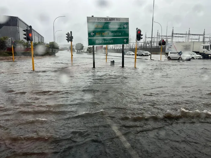
Residents from Cape Town to the Cape Winelands woke to dark skies, persistent rainfall, and growing concerns over flooding after the South African Weather Service issued an Orange Level Eight warning for disruptive rain, damaging coastal conditions, and potentially life-threatening flooding across multiple districts.
Forecasters warned that between two hundred and three hundred millimetres of rain could fall over mountain catchment regions during the current weather cycle, significantly increasing the risk of swollen rivers, overflowing stormwater systems, mudslides, and road closures. Along the coast, wind speeds are expected to reach between one hundred and one hundred and twenty kilometres an hour in exposed areas, while wave heights could exceed seven metres as a strong cold front moves across the south-western coastline.
Provincial authorities moved quickly.
Western Cape Local Government and Environmental Affairs MEC Anton Bredell confirmed that disaster response structures across the province had been placed on full operational readiness as the first storm bands began moving inland.
“This is a serious weather system, and residents are urged not to underestimate the risks,” Bredell said in an official provincial update.
“We are asking communities to avoid unnecessary travel, stay clear of flooded roads, low-lying bridges, and fast-moving water, and to monitor only official communication channels as conditions develop.”
Emergency coordination centres have now been activated across the Cape Metro, Cape Winelands, Overberg, Garden Route, and West Coast districts, with municipalities instructed to monitor flood-prone communities, informal settlements, river crossings, mountain passes, and coastal infrastructure.
Western Cape Disaster Management head Colin Deiner said operational teams remain on standby should evacuations or emergency interventions become necessary.
“All districts have activated response protocols, and resources remain on standby should communities require urgent assistance,” Deiner said.
He added that engineers, rescue teams, municipal response crews, and humanitarian partners are all monitoring conditions in real time.
The warning comes as many parts of the province remain vulnerable following a series of wet systems earlier this season, leaving some catchment areas already saturated. Disaster officials say that even moderate additional rainfall in certain regions could quickly trigger flash flooding.
Motorists have been urged to drive with extreme caution, particularly along mountain routes and low-water crossings, while fishermen, small craft operators, and coastal communities have been advised to remain off the water until sea conditions improve.
For thousands of Capetonians, the next twenty-four to forty-eight hours could prove critical as the province faces one of its toughest weather tests of the year.
Source: South African Weather Service – Western Cape Government – News24 – Sakhiseni Nxumalo